
| 南沙群岛地图 |
| |
|
|
首页
|
南沙群岛地图-古代历史地图 - 东洋南洋海道图
所有地图请看左边地图分类。 声明:本站所收集地图上所反映的信息不一定正确,不代表本站观点。 说明:四海总图的资料(2004-12-25日南沙群岛在线整理) -------- English Description: In Haiguo Jianwen Lu (Records of Sights and Sounds of Overseas States) written by Chen Lunjiong around 1730, the location of Qianli Shitang is described as follows: "South of (Wanli Chang)Sha there emerges strange stone banks all the way to Qizhou Yang. They are called Qianli Shitang. Sihai Zongtu (Comprehensive Map of the Four Seas) is the accompanying map which makes certain that Qianli Shitang refers to the Spratly Islands. 参考书目(References):
1. Lu Ning:Flashpoint Spratlys 地图图片 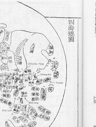
欢迎网友提供地图,联系我们。 |
||||
|
|