| 南沙群岛地图 |
| |
|
|
首页
|
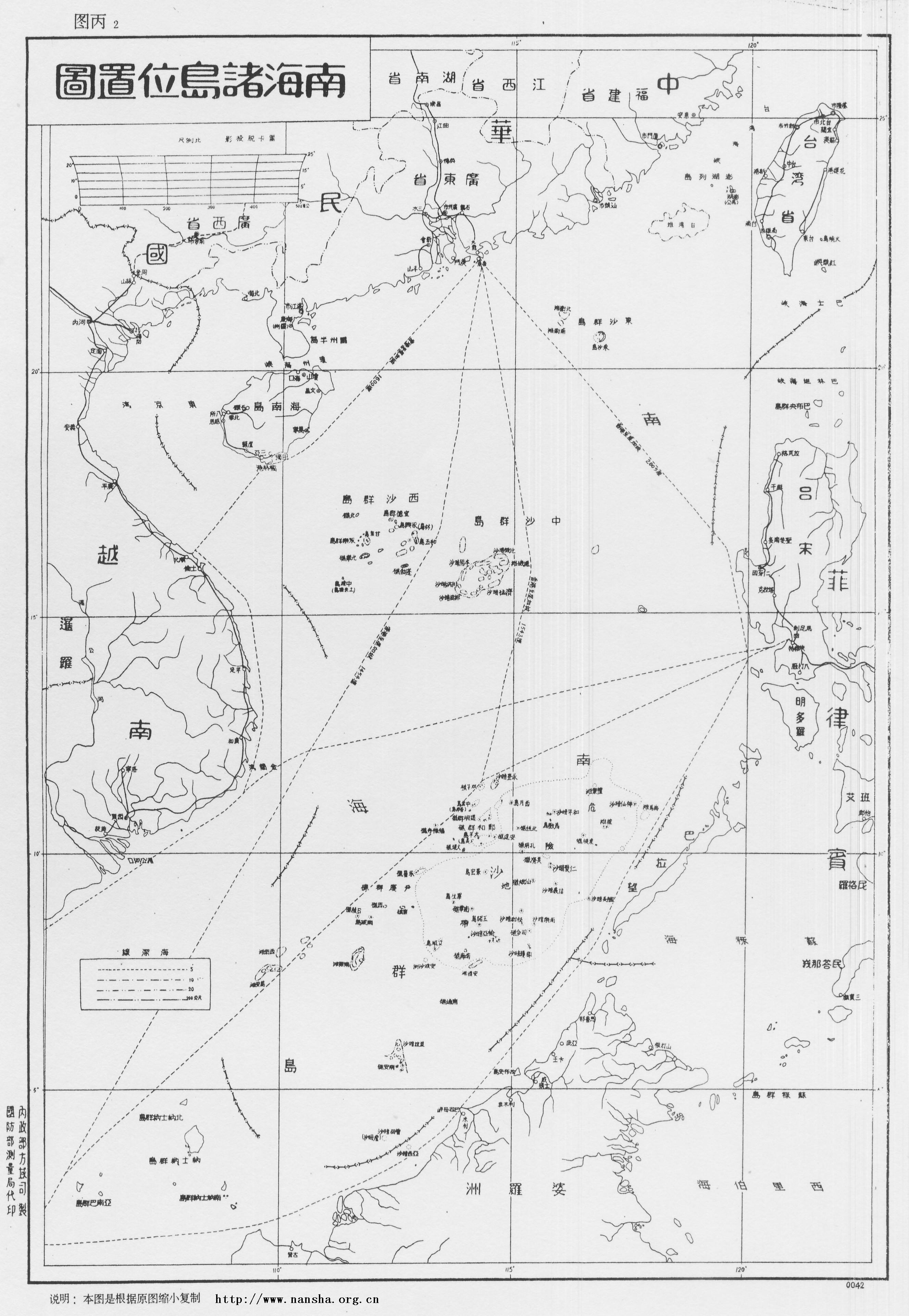
南沙群岛地图-1947 《南中国海图》(2005-07-20日南沙群岛在线整理, 2013-11-27更新)
说明:1947 《南中国海图》(Compiled from Various Sources to 1943), 1947年正月广东省政府秘书处编制。 图中详绘了东沙群岛、西沙群岛、中沙群岛,各岛屿有中英对照,海标均有深度,并附有说明。 中华民国三十五年十一月,行政院令海军总司令部、内政部协助广东省政府接收南海诸岛,并派太平舰、中业舰接收团沙群岛,永兴舰、中建舰接收西沙群岛, 同年十二月任务完成,为纪念太平舰、永兴舰之行之盛举,奉命将长岛改名为太平岛,林岛改名为永兴岛。本府以西鸟岛又名斯巴特列岛,远处南疆,特改为南威岛。 内政部为调整各群岛名称,复将团沙群岛(即日人所称之“新南群岛”,西人所称之Spratly群岛)改为南沙群岛,原曰之南沙群岛则改为中沙群岛, 以符诸岛在南海所处之位置。其余各岛洲礁多以历朝出任南洋使节之名以名之,以志纪念焉。 广东省中山图书馆藏 -------- English Description: 1947 Map of South China Sea Islands (published by Secretariat of Guangdong Province Government), Map of Nanhai Islands (South Sea Islands, then under the Administration of Guangdong Province Government together with Hainan Island since 1935). In 1946 (35th year of Republic of China), Navy Department sent navy ships Taiping, Yongxing, Zhongjian and Zhongye to take over Spratly Islands and Paracel Islands. To record these events, Woody Island of the Paracels was named after Yongxing. Spratly Island was named as Nanwei(literaly means South Power or South Might). The names of the four island groups were also adjusted to better suit and describe their positions. Xisha Islands (means West Sand Group, Paracel Islands, Paracels, now still called the same name), Dongsha Islands (East Sand Group, Tungsha Islands), Zhongsha Islands(i.e. Middle Sand Group, formerly named as Nansha, Macclesfield Islands, now called Zhongsha Islands, Zhōngshā Qúndǎo in Pinyin), and Tuansha Islands was renamed as Nansha Islands (i.e. South Sand group, Spratlys, Spratly Islands). This map clearly shows that China has long put these Islands under administration of Guangdong Province even before countries like the Philippines and Malaysia, Brunei were founded. 地图图片
地图来源 相关网页 欢迎网友提供地图,联系我们。 |
||||
|
|